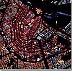
 A nifty bit of Dutch data visualization has been posted by the Waag Society: an interactive map with the age of every building in the Netherlands. Almost 10 million of them, color coded from oldest (dark red) to newest (bright blue). Amsterdam is depicted to the left, the oldest structures seen as glowing embers along the black rings of the canals.
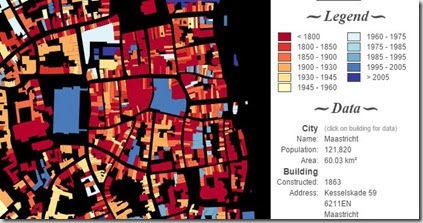
If I pan and zoom into Maastricht (counting my  building as the brown façade, third from the alley, right), the database shows that it was constructed in 1863, one of the younger buildings on Kesselskade. The Cle, left of mine, was built in 1800; the white building, right, in 1742.
The screen capture, above, has the Maas River to the right, Markt Square is top center (Stadhuis built in 1666), and the Vrijthof is left with the blue underground parking garage (1996) alongside the old red churches (1666 and 1734).

